
A call for local property deeds was put out at a recent talk at the Home Guard. Sue at 7 RPR provided hers, which date back to an Indenture or Conveyance dated 28 April 1910, within which there is a plan of the adjacent properties of 5 & 7 RPR.
Within the file there was the plan above, which has attracted considerable interest. It was posted with the intention that readers might want to study it and draw their own conclusions. It might now help to provide some interpretation.
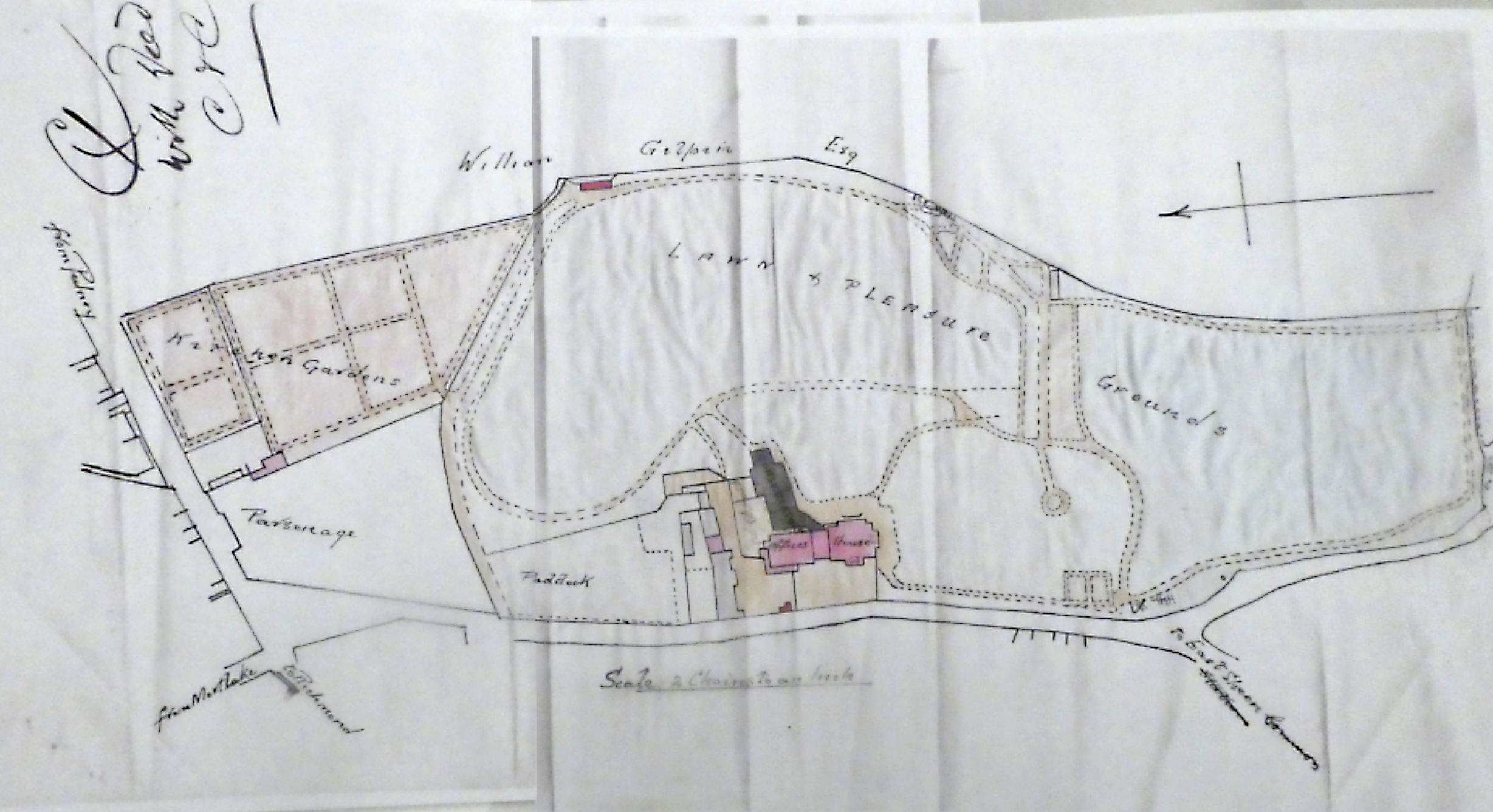
The previous post had some overlap. The version above is clearer. (Thanks to Paul Wiggins.) Note the North South direction. And note also the scale 2 Chains to an inch. A Chain is 66 feet and the sporting among you might note the connection to a cricket pitch.
The plan found within the file for 7 RPR is not dated but looking at the plan in detail, it must have been prepared in the 19th century. A wall surrounds what was Sheen House and its grounds, built in 1786 and demolished in 1907.
On the east side of Sheen Lane (bottom of the plan) there are traces of the Sheen House boundary wall from the junction opposite York Avenue round the bend to opposite Wayside and at the end of the Larches.
The plan shows the original buildings of Sheen House marked house and offices in pink. The dark grey area is marked Conservatory but that does not show on the 19th century photos of the property. The Land and Pleasure Gardens was, one might assume, the area where there was a cycle track. The light grey area could be the Coach House which is still there but now to the north of Shrewsbury Avenue.
Looking to the Upper Richmond Road, divided by the area of Muirdown Avenue, we have the Parsonage, now the site of Parkway House and Artisan. But no records of that Parsonage? And the Kitchen Gardens – the area was of course noted for its orchards. Who still has an apple tree in their garden?
The unbroken line under the words William Gilpin Esq (top of the plan) must be the wall which stretches the whole length of the east side of Richmond Park Road, separates it from Palewell Park and still exists.
The Ice Well marked at the top right hand is an interesting feature. Was it there to feed an ice rink or to keep food for the house cold? Where was it? Did it later feed the allotment in the Home Guard? Does someone have signs of it in their garden? Some of you may know the one in Kew Gardens.
Does anyone have any clues as to what the red mark between William and Gilpin might denote?
See also https://childlawobserver10.wordpress.com/wp-admin/post.php?post=954&action=edit for more on Sheen House.
Discover more from EastSheenMatters
Subscribe to get the latest posts sent to your email.
