

Recent Comments
butteryluckye3eac174… on Sheen Rocks! Richard AH White on Roadworks in Sheen Lane stephanie turner on Roadworks in Sheen Lane Richard AH White on Roadworks in Sheen Lane Dhun kenny on Roadworks in Sheen Lane
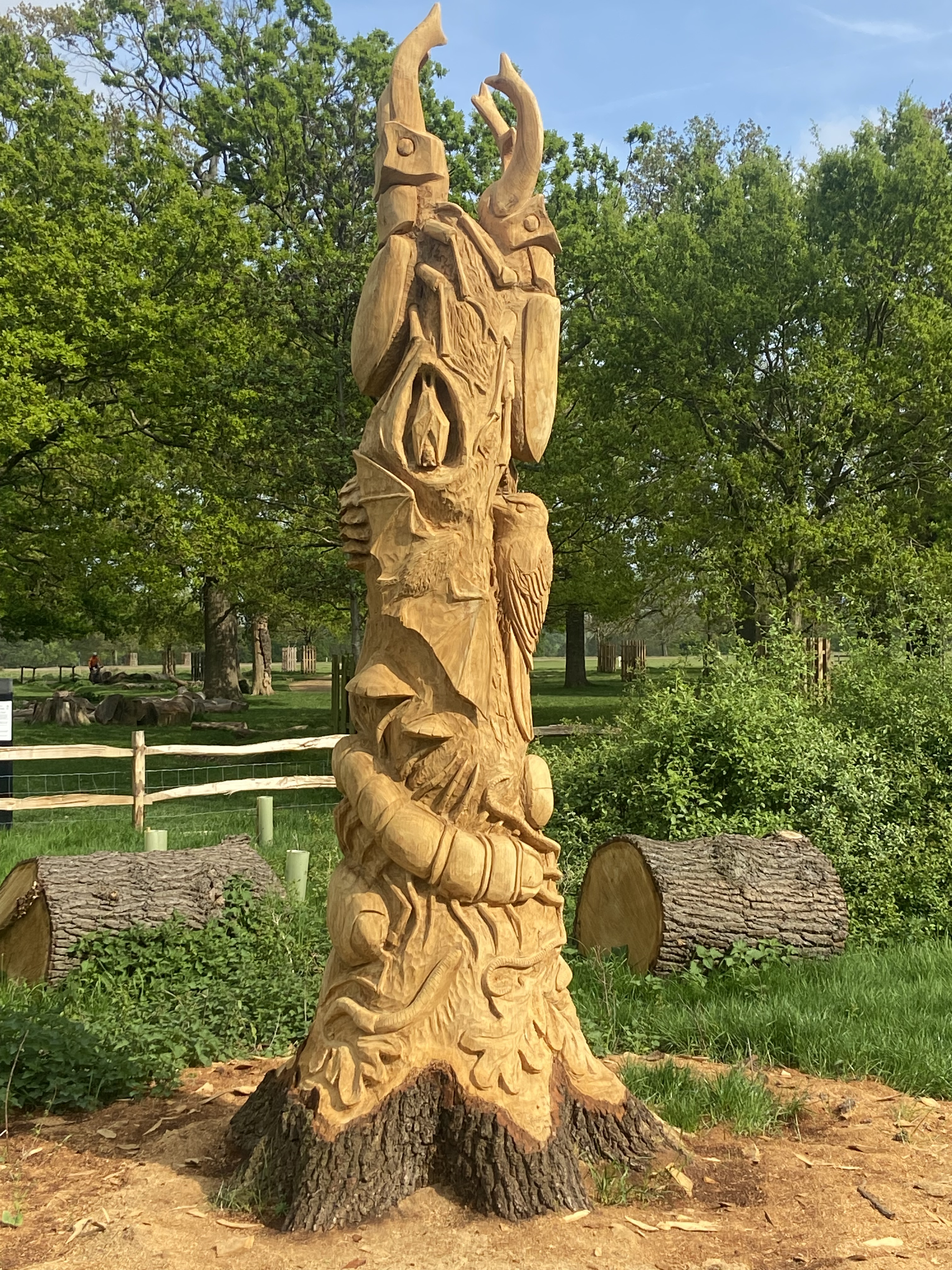
This wood carving near the car park at Sheen Gate is a must visit for closer inspection.
Paul Richards, Park Manager, writes:
The sculpture was inspired by the often-overlooked biodiversity found in decaying wood. Dead wood is a micro-habitat that is crucial to the biodiversity of our planet. A huge range of species – from woodlice to woodpeckers are dependent on dead wood. This sculpture highlights the crucial role that dead wood plays in sustaining healthy, vibrant ecosystems by showcasing intricate carvings of stag beetles, bracket fungi, centipedes, bats, woodpeckers and more.
The sculpture has been carved from a 5-metre tall oak stump which was removed due to Acute Oak Decline. As it weathers, the sculpture will provide food and shelter for the very species that it depicts.
Renowned wood sculptor Dan Cordell was commissioned by The Royal Parks through the charity’s Help Nature Thrive project. This project is possible thanks to the support of players of People’s Postcode Lottery.
After winning the Youngs Community Pub of the Year award on Thursday Lisa and Will are at it again.

Lisa (centre) winner with Will of the Community Pub of the Year award, with Emma (L), who works for Youngs and Amy (R) who works at the Pub.

This provides a quick summary. Go to the QR Code for the full Report.
Congratulations to Lisa and Will on the award.
You cannot currently bring meat or dairy products from any EU country into Great Britain for your own use. This temporary restriction is to help stop the spread of foot and mouth disease after recent outbreaks in Europe.
Given the informal nature of Michel’s sales from the car park, he is regrettably unable to continue for the time being. Tomorrow Saturday 26 April 2025 is likely to be the last day you will be able to get your cheese for a while. Michel is working hard to try to resolve the situation.
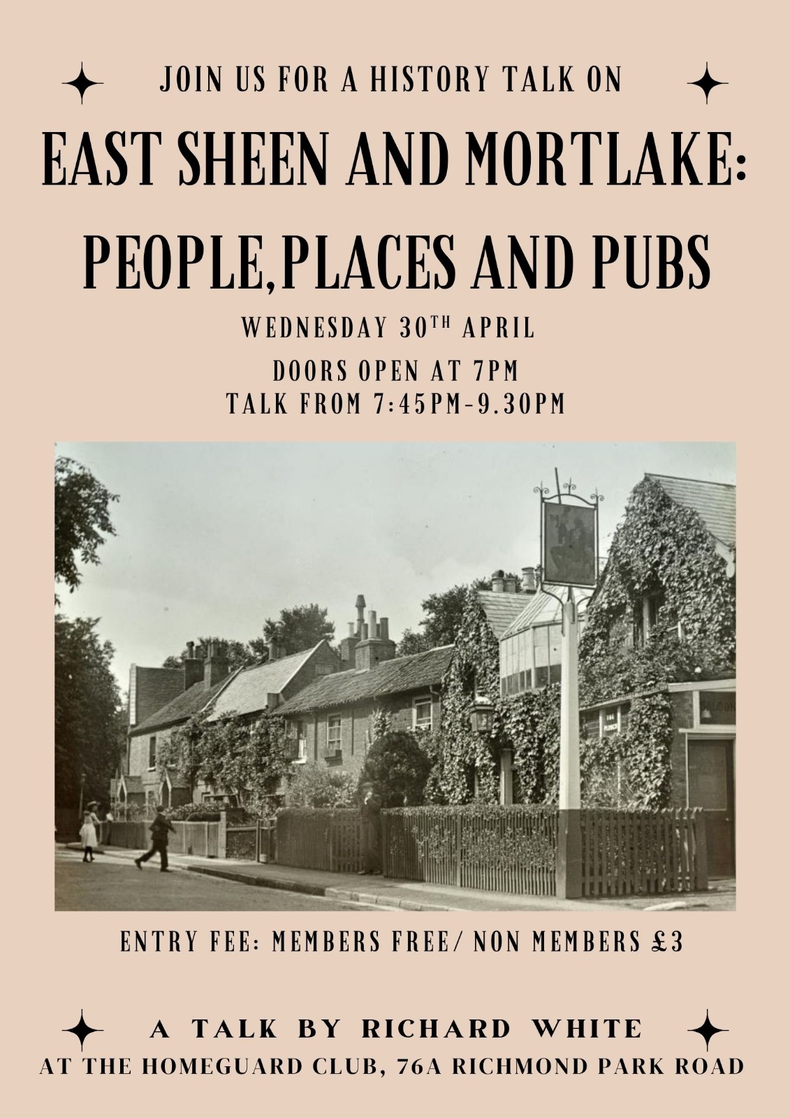
Following the interest shown for previous talks, a further event has been organised for an evening on Wednesday 30th April. (Some workers were not able to come during the day.)
Being an evening it will include more content on local pubs, existing, renamed, refurbished, demolished, those you may have drunk in but no longer can, reused, and those you may never have heard of.
Plus the history of Sheen House and the grounds of the Barnes Home Guard Club nd St Mary Magdalen’s Church Mortlake, and the Burton Mausoleum and the Vezlo Museum in the graveyard.
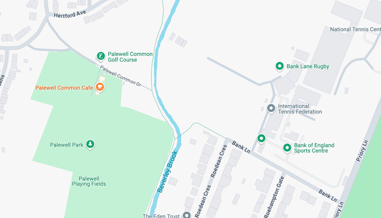
If you live in East Sheen and are familiar with Palewell Common – next to Richmond Park, near Roehampton Gate – you wouldn’t be surprised to hear of a road called Palewell Common Drive. Although it might sound familiar, if you were asked for directions to it, that might be more difficult. You won’t know anyone who lives on it, because nobody does.
But Palewell Common Drive does exist, running down from the wooded triangle at the top of Park Drive and Hertford Avenue (top left on Google Maps below), to the path to the bridge over Beverley Brook, or to the allotments if you turn left:
It’s only a proper road as far as the pitch and putt hut, after which it is for pedestrians and cyclists only.
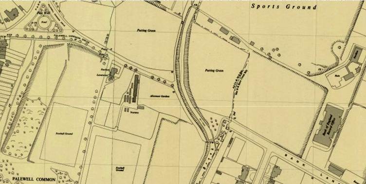
I became interested in this when someone posted a 1930s map online. I noticed that Palewell Common Drive used to be a different and more important road:
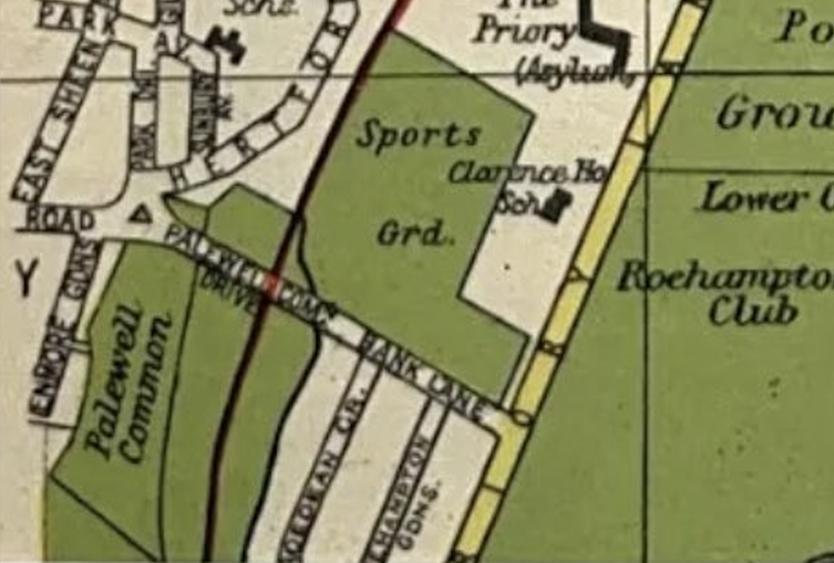
The map showed that PCD (as I’ll call it) joined up in a straight line with Bank Lane, the wide, sloping road down from Priory Lane which has the Bank of England Club entrance on the right as you come down the hill.
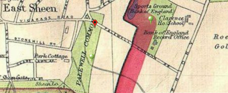
Another map from 1930, on The Underground Map, shows even greater glory for PCD, having it take over Bank Lane altogether and run all the way up to Priory Lane, across the border into the borough of Wandsworth:
If I’d been asked to guess where a straight extension of Bank Lane would end up, I’d have had it leading to the tennis courts on Palewell Common, with today’s PCD far off to its right. But I was wrong, as today’s Google Maps proves:
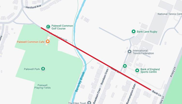
The only slight deviation from the line is that the pedestrian section of today’s PCD drifts a little to the left as it reaches the path to Beverley Brook. Apart from that, the two roads line up perfectly.
So it seems that in the 1930s you could drive from Priory Lane all the way into East Sheen, via PCD – or Bank Lane and PCD. Somewhere, probably a little to the right of where PCD reaches the footpath today, there must have been a road bridge over the stream. I haven’t been able to find any sign of it but a bit of digging would surely reveal something.
So when did the through road disappear? Well, before 1950, it seems. By then, according to this map from The Underground Map, the current arrangement was already in place (although there was still a pond in the middle of the triangle at the top of PCD):
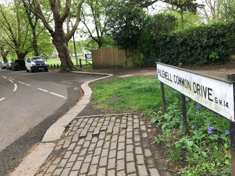
Knowing all this, when I made a visit, I noticed things I’d never seen before. First, there’s a proper sign by the triangle:
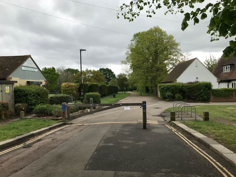
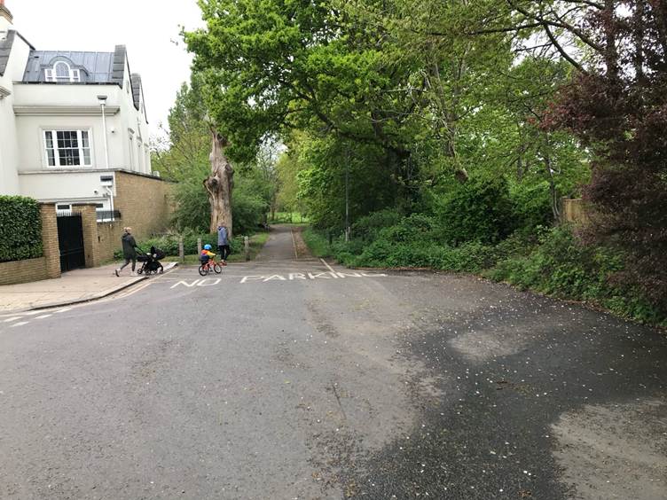
Second, PCD curves to the left on its way to joining the footpath at the point where it narrows from the full width of a road, suggesting, as my red line above indicated, that the old road was slightly to the right at that point:
And third, that if you look at the bottom of Bank Lane, you wonder why the road comes to a curious end, with a passageway as wide as the road but with just a footpath down the middle:
It’s great for the peace of the residential streets of East Sheen that you can’t drive through there today. I wonder whether that was why the change was made.
Does anyone know about this – or, even better, have old pictures that show PCD in its heyday?
Contributed by Charles Miller
| butteryluckye3eac174… on Sheen Rocks! | |
| Richard AH White on Roadworks in Sheen Lane | |
| stephanie turner on Roadworks in Sheen Lane | |
| Richard AH White on Roadworks in Sheen Lane | |
| Dhun kenny on Roadworks in Sheen Lane |
